Saturday, August 6, 2011

2011 Season Recap


Chases: 10  (4/4, 4/15*, 4/27, 5/19, 5/20, 5/21**, 5/22, 5/23, 5/24*, 5/25*)
Successful Chases: 9 (4/4, 4/15, 4/27, 5/19, 5/21, 5/22, 5/23, 5/24, 5/25)
Busts: 1 (5/20)
Storms Intercepted: 13
Tornadoes: 7  [Strongest: EF4 (5/24)]
Largest Hail Intercepted: ~1.75in [(Golfball sized) (Does not include HailSTONE collection)]
Strongest Winds Encountered: ~60 mph
States Chased In: LA, AR, MS, OK, KS, AL
Miles Driven: 6,089

*denotes days where tornadoes were observed
**denotes multiple tornadoes observed

Recap:

4/4: Targeted Northwest Mississippi with Cooper in hopes of intercepting semi-discrete cells out ahead of the ongoing MCS, as well as bowing segments within the MCS.  We succeeded in intercepting several semi-discrete cells that managed to produce sporadic quarter sized hail.  Unfortunately, the section of the MCS that we traversed gusted out before reaching our location north of Tupelo, MS, therefore no severe winds were experienced on a historic day for wind damage reports.

4/15: Forecasted semi-discrete cells to form south of an ongoing MCS due to outflow boundary interactions in Central LA early on this day.  This forecast verified, however class didn’t allow me to depart MLU until well after 10:00am.  At this point, the initial discrete cell matured into a supercell and produced an EF3 tornado in Jackson, MS.  I managed to salvage the chase by chasing all the way into far Eastern MS and extreme Western AL intercepting 3 different storms (1 originating from an outflow boundary, the other 2 from a “dry boundry”)  bagging two wall clouds and a semi-rainwrapped cone tornado near Quitmann, MS.

4/27: Did not intend on chasing on this day, however ended up in the middle of the Apocalypse on the way home from Dauphin Island, AL.  Cooper, Torres, Voight, Willis, Keys and I intercepted a strengthening storm near Crystal Springs, MS as it crossed I-55.  This particular storm featured two “hooks” at the time of intercepting.  We barely missed the first hook but managed to document and call in a rotating wall cloud associate with the second hook.  The gradient behind the dry boundary in eastern LA was among the strongest that I’ve ever personally experienced - extremely strong gusty winds made driving a challenge.

5/19: Day one of Project HailSTONE was met with a marathon drive from MLU to Wellington, KS beginning at 2am.  Operations commenced upon arrival in Wellington with a brief training before jumping right into the action.  The team intercepted several storms the weakened rapidly before intercepting a storm that produced decent results near Jetmore, KS that evening.  The day officially ended in Woodward, OK 24 hours after initially departing from MLU.

5/20: Day two of Project HailSTONE turned out to be a bust.  However, this provided valuable time to have a proper training session as well as bonding time with members.  Following training and practice, activities for the day included a heated game of rock curling, touring a wind farm, and climbing a mesa to watch a storm ~80 miles to our north at sunset.

5/21: Day three of Project HailSTONE was an epic day on many levels.  The team intercepted two supercells that featured incredible structure and produced ~5 tornadoes total (4 were documented by Cooper and I before going into collection mode).  To top this off, a successful data set was collected by the team.

5/22: Day four of Project HailSTONE was arguably the most difficult day mission-wise due to the HP nature of the storms.  The strength as well as the destruction produced by the Joplin, MO storm made collection and communication extremely difficult on this day.

5/23: Day five of Project HailSTONE was by far the most successful day of the project.  The team identified an Oklahoma record sized stone that was 6 inches in diameter.

5/24: The final day of Project HailSTONE was short lived due to the excessive forward speed of the storms as well as the high number of tornadoes.  Operations were called off and the team chased the tornado outbreak in central OK.  After nearly getting stuck on dirt and clay roads, Cooper and I rebounded and managed to punch into the hook of a tornado producing supercell near Chickasha, OK.  We were able to follow and document the EF-4 for the duration of its lifetime.

5/25: Before ending our spring season, Cooper, Kelley and I chased the high risk in northeast Arkansas.  We witnessed a brief tornado on our storm north of I-40 before chasing its persistent wallcloud into the flooded plains of northeastern Arkansas.  Cut off by the historic Mississippi River flood, we trekked back toward I-40 in hopes of getting on the next storm.  However, a very crowded I-40 prevented us from achieving this as the storm raced ahead of us into Tennessee producing a tornado around Memphis in its wake.

HailSTONE Identifies Oklahoma Record Stone

Project HailSTONE, the project in which me and Dylan participated in this past spring identified an Oklahoma state record hail stone (6 in. diameter) on 23 May 2011.  Read more about this exciting announcement at http://www.hailstoneresearch.org/may2311news.html

Saturday, March 12, 2011

March 5, 2011 Southern Louisiana Severe Wx


This past Saturday, March 5, 2011, southern Louisiana was rocked with another round of severe weather, with the primary storm modes being wind and tornadoes.  Unfortunately, this episode of severe weather proved to be both damaging and deadly, as a fairly short lived tornado produced EF2 damage in the town of Rayne, LA killing one person and injuring twelve others in its wake.  This was one of nine tornadoes that were produced across Southern Louisiana last Saturday, with four occurring in WFO LCH's CWA and five occurring in WFO LIX's CWA (County Warning Area).


What caused this event?
Through the analysis of upper air soundings and maps, I was able to identify several important features that were responsible for the initiation of this severe weather event.  In order for severe thunderstorms to occur, several conditions must be in place in conjunction with several atmospheric processes.  A moist layer of sufficient depth must be present in the lower to mid troposphere (including the boundary layer), instability, and source of lift (e.g. forcing from a front, upper level shortwave).  A fourth ingredient, wind shear, is crucial for the formation of supercell thunderstorms and tornadoes. 

This event initiated when several subtle shortwaves downstream of a well defined vort max passed over SE Texas and SW Louisiana, providing the lift needed for thunderstorms to develop.
 A series of subtle shortwaves are denoted by the red circle.  A well defined vort max (red area) can be identified over west Texas.  The "X" in this area denotes an area of maximum vorticity while the N to the north of this area denotes an area of minimum vorticity.  With the area of interest being downstream of this vort max, positive vorticity was advected into the area with time thus enhancing vertical lift over SE Texas and SW LA 
The 12Z sounding from WFO LCH profiled the atmosphere about an hour before the initiation of this event.  Multiple features in this sounding support the potential of severe weather.  The black boxes denote the depth of two significant dry layers in the atmosphere.  The wind profiler shows backed surface winds and veering winds with height.  Winds increase with height, thus indicating the presence of speed and directional wind shear.  The red box in this area of the sounding shows slight backing of the winds at upper levels, thus indicating slight cold air advective tendancies.  The "inferred temp advection" graph supports this observation, denoting temperatures decreasing at rates of 0.6 and 0.7 degrees Celsius per hour.  The hodograph in the top right area of the picture supports the observations made from the wind profile.  This tool shows how wind direction and speed change with height.  0-1 km shear (denoted by the black box) indicated that the atmosphere was conducive for rotating updrafts.  Despite these features, a weak capping inversion in the lower levels was inhibiting convection at the time the atmosphere was profiled (SB CIN values of -46 and ML CIN values of -149).  This cap quickly eroded in the hour following this sounding and allowed thunderstorms to develop.  

The Event
The image above is a base reflectivity overview of the entire MCS.  The red "L" just to the south of the Louisiana coast (Cameron Parish) denotes the location of the subsynoptic low that influenced storm motion.  The black arrows show the differences in storm motion with respect to distance from and location around the low.  Convection well ahead of the main thunderstorms featured a northerly component of motion whereas activity behind and north of the low featured a southerly component of motion (air rotates counterclockwise around low pressure systems in the northern hemisphere).  The main convection associated with this system moved to the eastnortheast as the entire MCS propogated to the east. 
Surface observations around the time of initiation (~13Z).

Jefferson Davis EF0's
This is a base reflectivity (BR) and storm relative velocity (SRV) image the supercell thunderstorm that produced two EF0 tornadoes in Jefferson Davis Parish.  At the the screen shot was take, the second EF0 tornado was in progress.  The base reflectivity product features an impressive signature that supports the strong velocity couplet that is featured in the SRV product.  The BR image shows areas of higher reflectivity associated with heavier rainfall "spiraling" toward the area of lower pressure where the mesocyclone and tornado were located.  The behavior of the rainbands is a direct result of the strong inbound/outbound velocities that are shown by the SRV product.  The red arrow in the BR image denotes modified inflow air (modified by wetbulb cooling at the surface due to rainfall) being advected into the inflow notch to the northeast of the mesocyclone and tornado.  This particular storm eventually gusted out as a rear inflow jet built into the area, leading to several more tornadoes, including the Rayne EF2.

Crowley & Rayne Tornadoes
Both the Crowley tornado (EF0) and the Rayne tornado (EF2) were the result of bookend vorticies, as a rear inflow jet built into the area.  This inflow jet may have been the result of wet-bulb cooling occuring in the mid-levels of the thunderstorm that was located just to the west of the HP supercell that produced the Jefferson Davis Parish tornadoes.
In this series of photos, I utilized the base reflectivity (BR), storm relative velocity (SRV), echo top (ET), and normalized rotation (NROT).  The echo top product shows cloud top heights.  The NROT product is an algorithm that was developed by the makers of GR Analyst.  This product features a range of -5 to +5. Anything above 1.0 is significant and values above 2.5 are extreme.   A detailed explanation of this product can be found here: http://grlevelxstuff.com/forum/showthread.php?t=314.

The BR product in the photos above show streaks of lighter reflectivity in the trailing stratiform precipitation behind the tornado producing thunderstorm.  This signature suggests the presence of a rear inflow jet.  This occurs as strong winds change the direction of rain droplets from vertical to horizontal, thus preventing the radar beam from intercepting some these droplets and leading to lighter reflectivity returns.  The series of photos also shows the evolution of the velocity couplet, with it being the strongest and tightest over the city of Rayne.  Gate to gate velocity (inbound/outbound velocity combined) was 85 knots and NROT values were 1.53 at the time.  Echo tops associated with this storm peaked ~41,000 feet.

All together, 683 homes were damage with 42 being completely destroyed and 48 receiving major damage in Rayne.  Unfortunately, these two tornadoes injured a total of 15 people and killed one woman when a tree fell on the house she was in. 

How does a bookend vortex form?

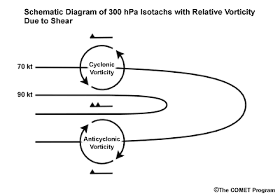
Bookend vorticies are the result of shear vorticity (a form of relative vorticity).  The photo above illustrates this process very clearly.  As strong winds move through an area, it creates areas of vorticity on both sides of the area of strongest wind.  This is the same principal as dragging your hand in bathwater.  The water that is not being pushed by your hand has a tendancy to rotate away from the area of forcing, thus creating vorticity on a small scale.  Although the image above is a model of this principle at the 300 hPa level, this can occur at any level in the atmosphere.


Southeastern Louisiana Tornadoes
The tornadoes that were produced in southeastern Louisiana were also the result of a shear vorticity/bookend vortex situation.  Of the five tornadoes in this region, four were EF0's and one was rated EF1.


These two cases from SE Louisiana explicitly show the same radar signatures that the Crowley and Rayne storms exhibited.  Bookened vorticies and areas of rotation are depicted by the black circles in each image.


What lessons were learned?
In conclusion, March 5, 2011 is another classic example of the kinds or tornadoes that we are faced with in Southern Louisiana and throughout the southeastern US.  Unlike many cases from the Great Plains, tornado producing storms in the south are often messy storm structure wise, making them much more difficult to detect and dangerous to chase.


Sunday, March 6, 2011

South Lousiana Bookend Vortex

This past December 29, Southern Louisiana experienced a severe storm.  Little damage was done, with the only damage reports coming from the Intracoastal City area in the form of downed trees.  An 80 mph wind gust was recorded from a private weather station in the Mouton Cove area and a 60 mph wind gust was recorded at the KATC-TV3 station in Lafayette, LA.  Tornado warnings were issued by the NWS offices in Lake Charles and Slidell, due to the threat of brief tornadoes along the front of the MCS and associated with the bookend vortex on the north side of the MCS.

The 0Z sounding from WFO LCH showcases several interesting features that led to the initiation of this event.  While surface based CAPE values were only ~550 J/Kg and surface temperatures were in the lower 60's, several factors led to the destabilization of the atmosphere.  First, the area's in the blue circle and red square show significant dry air layers.  This is important, because these dry layers steepen lapse rates (temperature decrease with height) aloft, thus allowing the mid levels of the troposphere to destabilize.  The significance of the second dry layer ~650mb is not known due to the failure of the carbon hygristor (measures atmospheric humidity) in the radiosonde at this level.  The stratification of this particular layer (shown by the orange circle at 450mb) suggests the end of this dry layer.  However, due to the absence of data at this point, this statement cannot be made with confidence.  Finally, backing of the winds in the upper levels (as denoted by the green box in the wind profile) suggests cold air advection aloft.  This is significant, because this increases lapse rates aloft, thus further destabilizing the atmosphere (a warm air parcel rises more rapidly with colder air surrounding it).

The radar images above shows the MCS bowing out around the Intracoastal City area.  The rear inflow jet (RIJ) can clearly be seen in both base reflectivity and storm relative velocity products.  The RIJ is the reason why an 80 mph wind gust was recorded around the Gator Cove area.  The RIJ is also directly responsible for the bookend vortex (denoted by the blue circle) that formed on the north side of the MCS.  It was this feature that prompted a tornado warning for parts of Vermillion, Iberia, and St. Martin Parishes.  Although no tornado occured in this case, many tornadoes that occur with derechos occur in these bookend vorticies, therefore the warnings from the WFO LCH were justified. 

Sunday, January 9, 2011

2010 Chasing Recap


Chases: 8 (1/20, 1/23, 3/27, 4/2, 4/24*, 5/1**, 5/19*, 12/31)
Successful Chases: 5 (3/27, 4/24, 5/1, 5/19, 12/31)
Busts: 3 [1/20 (class), 1/23, 4/2]
Storms Intercepted: 12
Tornadoes: 5 [Strongest: EF4 (4/24), Weakest: EF0 (5/1)]
Funnels:4
Wall Clouds:12
Largest Hail Encountered: Dime sized (.75 in)
Strongest Winds Encountered: ~80 mph
States Chased In: LA, AR, MS, TX, OK

*denotes days where tornadoes were observed
**denotes multiple tornadoes observed

*Note that the tornado on 5/19 was rainwrapped and was picked out of the rain due to violent left to right motion during post chase video analysis.

*Also, rain wrapped tornado was witnessed on 12/31, however funnel could not be seen, nor could violent left to right motion be made out in the rain.  Power flashes were observed however.

Recap:

1/20:  First tornado outbreak of the new decade.  Clay, Cooper and I could not get out early due to an afternoon class.  This caused us to miss the show, including the EF-3 tornado that impacted Waskom, TX.

1/23:  Still reeling from the missed opportunity, Clay, Cooper and I chased a marginal slight risk across Southern Arkansas and busted badly due to a lack of instability.  Thank you stratus clouds!

3/27:  Targeted Central Arkansas while most other chasers targeted the OK/MO border due to a greater tornado risk.  Enjoyed an LP supercell event across central Arkansas and intercepted multiple storms for the first time.  I witnessed the hail shaft of one of the storms cross I-40 during rush hour just outside of LIT.  I also experienced ~60 mph winds 4 miles north of Stuttgart associated with a bowing segment in the squall line that formed after the sun set.

4/2:  Still feeling chase fever, I joined Wheeler, Cooper, and Ostarly on a slight risk chase over NE Texas.  I initially targeted Mt. Pleasant, TX, however we hung out in SHV and accessed the situation due to lingering stratus that was surpressing daytime heating over the target area.  Storms did initiate and went through the target area, but were only marginally severe at best.  Again, morning crapvection and stratus won the battle that day….

4/24:  This was a day of firsts.  I finally intercepted my first tornado with Cooper in the Mississippi Delta.  Unfortunately, it was a killer EF4.  We also witnessed extensive tornado damage for the first time.  In addition, I experienced the worst RFD to date associated with that storm and punched into the “bear’s cage” for the first time on this day.

5/1:  Witnessed multiple tornadoes for the first time across Central Arkansas.  All of them were brief however, leaving me feeling teased by Mother Nature at the end of the day…

5/19:  Didn’t do the best job at forecasting on this day and played catch up for most of the afternoon.  Cooper and I did witness a rainwrapped tornado around the Dover area as we were moving north to get in better position to intercept the storm.  We also witnessed a brief funnel that got halfway to the ground as the storm was gusting out.  This was not my favorite chase for a lot of reasons, but mainly due to the insane amount of traffic.

12/31:  Chased in the Louisiana Delta region and across Central Mississippi with Cooper.  We bagged two wall clouds on a single storm as it went through a cycle just west of Newellton, LA and witnessed a rain wrapped tornado move through the Richland/Pearl/Jackson, MS area.  However, no violent left to right motion was noted from our location and we did not see the condensation funnel.

-JP

Another Successful Pre Holiday Chase


I departed NIB around 8:30pm CDT on Thursday evening to travel to MLU to meet with Cooper for what would be a slight risk chase across the western parts of Dixie Alley.  A new challenge for myself in forecasting this system was the fact that there were multiple target areas, including the NW Arkansas and the Ozark region of Missouri which is mostly bad chase area (with the exception of a few areas in Missouri).  In addition, storm motion was going to be far faster than what is ideal to chase in these areas.  Fast storm motion and poor road networks usually spell disaster.  Taking all of this into account, we decided to play the southern scenario and initially target East Central Mississippi between Vicksburg and Jackson.

 After a few hours of sleep, we awoke to semi discrete supercells racing across NW Arkansas producing several tornadoes in its wake.  Being sorely out of position and having no desire to be playing catch-up with these fast moving storms, we decided to stick with our target area of East Central Mississippi.  Cooper and I departed MLU around 9 am on Friday with an initial target of Vicksburg, MS.  However, with storms already developing in the favorable thermodynamic environment that was present over SE Louisiana, I decided to target Jackson initially due to more road options.  

We arrived at our target area around 11:30 CDT and began staging.  The storms that formed over SE LA were tracking further east toward the jungles of West Central MS and were going into HP mode as expected.  Meanwhile, a weak storm cluster formed just to the northeast of Lake Charles, LA.  Based on the thermodynamic and dynamic environment that was present across all of South Louisiana, we decided to drive back toward Vicksburg and monitor the situation from there with viable road options to take us south and west.

In Vicksburg, Cooper and I noted the increasing temperature and moistness of the air.  The SREF and RUC models were both indicating that a Theta E ridge (see http://www.theweatherprediction.com/habyhints/324/ for more info) was building north toward the I-20 corridor, with the main axis building in between Tallulah, LA and Vicksburg, MS.  I noted that the storm cluster that formed NE of LCH was following the theta e ridge to the northeast, and it was only a matter of time before these storms were going to intensify and go severe.  Therefore, Cooper and I decided that it would be best for us to reposition further west to cross the Mississippi River to have a change to intercept these storms before they merged into a squall line.

As we mobilized, the southernmost storm in the targeted broken line of storms went supercellular prompting a tornado warning from the NWS LCH, as this storm was in the extreme northeastern part of their CWA.   Noting the track of these storms to the northeast and considerably slower storm motion (25-30 mph at this time), Cooper and I took Highway 65 south to attack a cell in the middle of the broken line the was beginning to show signs of forming a mesocyclone.  As we began moving south, the storm that was targeted went supercellular and was warned on by the NWS in Jackson, MS.  Around this time, we were inconvenienced by the loss of mobile internet.  However, with the help of several nowcastors and visual knowledge, we were able to put ourselves in position for a good intercept 4 miles west of Newellton, LA along State Highway 4. 

After sitting for about 20 minutes watching to storm, we were rewarded for our patience as the wall cloud associated with our storm appeared out of the rain.  Very weak rotation was observed with this wall cloud.  After calling it in to WFO JAN as well as capturing stills and photos of it, we decided to move north on Hwy 65 and parallel the wall cloud rather than sitting and waiting for the next storm.  This decision was made in an attempt to 1) stick with that particular storm and 2) get back across the Mississippi River as soon as possible, as the severe threat was beginning to shift further east as the broken line of storms began to merge into a squall line. 

On our way north, we ran into fellow chasers Conner McCrorey and David Reimer of Texas Storm Chasers and Scott Peake from OU, who were also on the same storm.  As both teams continued north tracking the storm, we experienced a new wall cloud with this particular storm passing over the top of both of our vehicles.  As it crossed the Highway, I noted weak vertical motion and little to no rotation associated with the wall cloud itself.  The storm still retained supercell characteristics, as both teams were slammed with a very wet RFD containing ~60-65 mph winds.  Due to the brief delay in the RFD reaching our location on the road after the wall cloud passed over us, I was able to infer that there was still broad rotation associated with the storm itself.

After punching through the newly developed squall line around Jackson, MS, Cooper and I targeted a discrete supercell with a confirmed tornado ahead of the main line that was translating NE toward the Jackson Metro area.  With the lack of daylight left and poor terrain (lots of trees), I decided it was best to not punch the bears cage with the hope of getting a brief glimpse of the tornado. In addition, storm motion was much quicker (~45 mph) due to an increase in low level jet (850mb) wind speeds.  Instead, we tracked a little further East to Highway 49, where we drove south into the town of Richland.  There, we watched the rain wrapped tornado translate across the highway about 3 miles to our north noting power flashes and inflow winds well beneath the severe threshold.

Around this time, WFO JAN issued a Tornado Emergency for the city of Jackson, as this tornado was moving toward the city.  After about a 5 minute wait, we decided to follow this storm toward Brandon, the next town east of Jackson on I-20.  As we tracked East toward Brandon, we noted several power flashes associated with the tornado as were pushed around by winds in access of 55-60 mph in the backside of the storm.  We also ran across tree limbs in the road around mile marker 50 on I-20, just a little damage associated with this EF-2 tornado. 

Around this time, we noticed another cell to our southeast that was beginning to go supercellular.  We managed to get ahead of this storm on I-20 before driving south on state highway 13 toward the town of Polkville.  Despite the terrible terrain, we managed to find a small hill next to a clearing in the dense tree canopy to watch the storm approach our area.  However, the storm gusted out before reaching our location and managed to recycle off to our Northeast.  However, due to the lack of light, we decided to call it a chase.

Special thanks to Don Wheeler of LA Delta Community College and Brandon Thomas from the Alabama Storm Trackers for nowcasting assistance!

Chase Stats
Storms Intercepted: 4
Wall Clouds: 2
Highest winds: ~60 mph
Largest Hail: Dime sized (.75 in)
Miles Driven: 990

 Our location relative to the rainwrapped tornado as it moved toward the Jackson area.  Courtesy of Don Wheeler LDCC.

-JP