| Photo Courtesy of Don Wheeler. |
Wednesday, March 27, 2013
Four Years Ago Today
Sunday, August 12, 2012
Thank You AES!
I would like to take another opportunity to thank all of the employees at Accuweather Enterprise Solutions for a great summer experience as a Forecaster Intern. Everyone's hospitality made the big move much easier for me, and made me feel very much a part of the team at AES.
To the meteorologists in ops: I learned quite a bit from each and every one of you this summer, especially when it came to all of your different styles of contouring maps. I also want to thank you guys for giving me the opportunity to issue warnings. I issued my first warning on my birthday (June 7) and that was probably the most unique and coolest present I've ever received. I appreciate everyone's patience with me when things didn't necessarily go right (usually something I did wrong on Canvas from time to time). Lessons were learned from those mistakes and improvements were made over time because of this.
To the morning crew: sorry I wont be around to get SWD done in my usual brisk pace. I do hope the number of severe reports on a daily basis decreases soon for you guys. Overall, I think the thing that I will miss the most is the work atmosphere in ops. Things were accomplished, but at the same time, you guys made work fun. The Guy impersonations, Eddie and Dewvall's movie trivia that I failed 90% of the time, the jokes about my age, the music (I will probably never listen to "Don't Stop Believing" ever again thanks to Becky), and so on made me want to drag myself out of bed every morning and look forward to coming into work, despite the amount sleep I may have missed out on the night before from shenanigans (failed attempts to view auroras and driving to and from North Dakota for 2 days of non-stop chasing come to mind). It all made the entire experience worth it for me personally and I hope to see you all again in the future.
-JP
Saturday, August 11, 2012
Oklahoma Hailfest: 29 May 2012
Upon completing another work week, the pattern remained active for severe storms across the Southern and Central Plains with much of Oklahoma being under the threat for hail and high winds. Taking this into account, I decided to team up with a few of my new coworkers for a fairly short chase into northwestern Oklahoma.
Collectively, Crouch, Danna, Elliot, and I decided upon an initial target area of Alva, OK, setting a time frame for initiation between 4 and 5 pm. Unlike May 25, the chance for tornadoes were slim at best, with mesoscale influences being necessary for tornadogenesis to take place in any storm in this particular environment. However, the setup favored large to giant hail, as all soundings around our target area (LMN, OUN) featured one or more significant dry layers, thus steepening lapse rates considerably. Taking all of this into account, we loaded up and departed from ICT shortly after 2:30 pm and moved southwest toward our target area.
 |
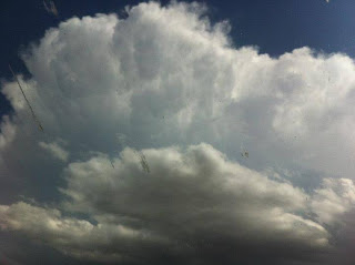
| Initial convection over our target area of Alva, OK. Photo courtesy of Becky Elliott. |
 |
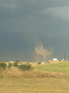
| Fairly large dust devil on the backside of our storm as we drove into Alva, OK. Photo courtesy of Becky Elliott. |
Unfortunately, our plans were short lived as storms south of our location began to form and split. The right movers of the spilts that took place raced off to the north, with one particular right split blindsiding us from the south. Sporadic baseball sized hail greeted us and we quickly opted to turn around and escape before getting hit and potentially losing windows and the windshield. Having to reassess our strategy, we decided to move south on Highway 8 toward Fairview, Oklahoma in an effort to stay ahead of a well defined outflow boundary that was put off by the initial cells.
 |
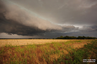
| Shelf cloud on the leading edge of our storm west of Ames, OK. |
 |
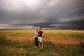
| Kate and Crouch take advantage of a photo op. |
 |
| Becky is thumbs up as she cures her "SDS". Photo courtesy of Becky Elliott |
 |
| A weakening storm produces virga as the sun sets in the foreground. Photo courtesy of Becky Elliott. |
Distance: 508 miles
Wx: Baseball sized hail, structure.
Tuesday, August 7, 2012
First Tornado of 2011: 15 April 2011
I never published this particular account from one of my only freelance chases of 2011. Although overshadowed by the devastation of April 27, the April 14-16, 2011 outbreak was one of the more significant outbreaks of the 2011 season. I was able to get out of class in time to experience this day in the field as supercells developed across the southeast.
Utilizing a
combination of the NAM WRF, European, and RUC HRRR model runs, I forecasted the
initiation of a discrete thunderstorm in West Central Louisiana in Toledo Bend
country around 6am CDT. This forecast
came to fruition, with three storms initiating along an outflow boundary
produced by an ongoing MCS from the previous afternoon over the Ark-LA-Tex
region. Of the three storms that
initiated, the northernmost storm became the dominant storm eventually going
supercellular as it moved into a more favorable shear environment east of the
Mississippi River. This storm went on to
produce an EF-3 tornado in Jackson, MS.
Due to class responsibilities, I wasn’t able to depart KMLU
until 10:30am CDT. I initially targeted
a discrete cluster of cells that formed along the cold front associated with
this very dynamic storm system. As I
approached this small cluster of cells, I noted that the bases of these storms
were extremely high, despite the fact that the southernmost storm featured
notable rotation in the upper levels of the storm. At this time, I noticed only modest forward
storm motion speeds (~30 knots) associated with the discrete supercells in East
Central Mississippi. This prompted me to
continue driving eastward toward this are to put myself in position for further
convective development to the south.
As I approached the Jackson metro area, I encountered a
major traffic jam that was the result of damage caused by the EF3 tornado that
was associated with the initial discrete cell of the event. To add to this problem, two new discrete
cells were beginning to go supercellular and were heading toward the Jackson
metro area. This forced me to have to
detour around a large stretch of I-20.
Once I was able to exit the interstate, I drove north on the Natchez
Trace Parkway before driving East through Jackson on highways 49 and 25. This took me out of position to make a play
on the two cells south of I-20. However,
both cells possessed easterly components that the first cell did not. This allowed me to get back on I-20 and get
ahead of the northernmost storm to set myself up for an intercept around
Meridian, MS. As this storm approached
my location in Meridian, I observed and documented the forward flank downdraft
advancing on my location. Extremely warm
and moist air was noted before precipitation started. Shortly after precipitation began, I observed
a large rapidly rotating wall cloud about a mile to my south. I was able to observe the rain curtains
“wrapping” around the wall cloud itself all the way to the surface from my
location. After documenting and
reporting this to the National Weather Service, I decided to continue tracking
east into Western Alabama.
Upon further investigation of my storm’s characteristics on
radar, it was evident that it was beginning to become and HP mess and was
losing strength. Therefore, I decided to
drive south in an effort to intercept the southernmost storm of the
cluster. However, I ran into another
road block due to previous tornado damage, and was forced to turn around and
re-strategize. With additional
semi-discrete cells forming along the cold front in southwest Mississippi, I
decided to reposition to the south along US 45 in Eastern Mississippi to wait
for storms to come to me. This strategy
allowed me to intercept two more storms on this day. I observed, documented and reported a tornado
that crossed US 45 southeast of Quitman and a rotating wall cloud that crossed
US 45 about 2.5 miles south of Waynesboro, MS before deciding to call it a
chase. This chased ended when I arrived
in NIB shortly after midnight on the 16th.
 |
| Wall Cloud associated with the southernmost cell that formed along the cold front in western Misissippi and southern Louisiana. |
Chase Stats
Storms Intercepted: 3
Wall Clouds: 2 (Meridian, MS, 5.5 S Waynesboro, MS)
Tornadoes: 1 (Quittman, MS)
Hail: Pea Sized (Quittman, MS)
Distance: ~800 miles
Wednesday, August 1, 2012
Slight Risk, Big Reward: 25 May 2012
 |
| Initial wall cloud and associated "Beavers Tail" (left) feeding moisture into the storm. |
 |
| Dust and dirt being lifted into the updraft as the storm strengthened. |
 |
| Close CG strike during HailSTONE collection. |
 | |||
| Cooper and Bosco observing the recycling wallcloud that was in the process of producing funnel clouds as a CG strike occurs nearby. |
Wx: 1 Tornado, Hail, many CG Strikes & Gustnadoes
HailSTONE 2 Day 7: 23 May 2012
The next morning began extremely early as the two target areas in consideration were pretty far away from Watertown, SD. After deciding on a target of Eastern Nebraska, the team set off on I-29 once again for another lengthy drive. The team arrived at the target area early for the second day in a row, which allowed the team to have some downtime while waiting for convective initiation.
 |
| The team killing time on a hill north of Lincoln, NE. |
 | |
| There were strong surface winds gusting at high as 33 mph at times. |
Once convection initiated, the team immediately went into collection mode on storms west of Wahoo, NE. Already experiencing a barrage of computer problems, my afternoon got a little worse as I found myself stuck behind several locals and other chasers. This impeded my progress enough to allow the hailcore from another cell south of our initial storm to overtake me and collection 1 on our east/west road. After surviving several uncomfortably close CG lightning strikes and some questionable driving from those around us, we were able to clear the hailcore just as the meso was approaching our east/west road. After continuing another 3 miles east to get further ahead of the core, I found myself underneath the meso just as a gustnado spun up just east of my north road option.
 |
| A rather well defined but brief gustnado crossing my east/west road. Image taken by the dash cam. |
Distance: 2,181 miles
Tuesday, July 24, 2012
HailSTONE 2 Day 6: 22 May 2012
After leaving work on May 21, I prepared for what would be my second marathon drive in a week's time to meet up with Project HailSTONE for the first time in 2012. I departed ICT for Watertown, SD around 3:30 pm and finally arrived shortly after midnight on the 22nd. After a short night of sleep, the PI's held the morning briefing deciding on a target area of Bismark, North Dakota.
The team departed Watertown, SD ~10:30 am to get in position to wait for convective initiation north of Bismark. After a few car issues (including my data card antenna getting blown off of my roof again), ice cream sandwiches for good luck, and footraces down dirt roads, the cold front had overtaken us without convection initiating due to abundant stratus clouds in the area. Taking this into account, the team repositioned to the east and was able to salvage the day by intercepting a cluster of storms south of Jamestown, North Dakota during the evening hours.
The team decided to trek eastward across South Dakota and brave gusty outflow winds (measured ~50mph; 5-10mph error) from collapsing storms to return to Watertown, SD for a short night's rest.
Subscribe to:
Comments (Atom)


